Kobe is a beautiful city. Moreover, its scenery is not uniform but remarkably diverse, its many changing faces comparable to a kaleidoscope. This essay attempts to express the charm of these varied landscapes through the traditional format of the “Eight Views,” as seen in such celebrated sets as the Eight Views of Ōmi and the Eight Views of Kanazawa.
Kobe’s richly contoured terrain—where land, sea, and sky contend with one another—creates numerous magnificent vistas at their points of convergence. Yet this very abundance can sometimes diffuse the city’s overall image. By deliberately framing the subject within the discipline of a set form, we seek to carefully select and present representative scenes. The “Eight Views of Kobe” are eight carefully chosen locations that together offer a three-dimensional understanding of the city and highlight a beauty unique to Kobe, born of its geography and history.
View One: Meriken Park as Seen from Harborland

The first view presents Kobe Port as seen from the urban district. The familiar Kobe Port Tower and the sweeping roof of the Kobe Maritime Museum stand beautifully against the blue sea and sky. This angle corresponds to that of the famous ukiyo-e print Sesshū Kobe Kaigan Han'ei no Zu (Prosperity of the Kobe Coast in Settsu Province).
View Two: Kobe Ohashi Bridge and the City from North Park

The second view is the cityscape of Kobe as seen from the sea. From Port Island, an artificial island, one sees the vast Kobe Ohashi Bridge stretching toward the city center, backed by the Rokko mountain range rising like a folding screen—an unmistakably Kobe landscape. When a large passenger ship is in port, it further enhances the scene.
Although other vantage points on Port Island—such as Shiosai Park with its “BE KOBE” monument and the Portopia Hotel—offer fine views, North Park, with Kobe Ohashi Bridge directly before it and the striking contrast of blue sea and sky, is chosen as the foremost.
View Three: The Kobe Cityscape from Mount Shishō

The third view looks down upon Kobe from the Rokko mountain range. One can clearly see how the city spreads out around the harbor. From here, the Port Tower seen in the first view, Port Island and Kobe Ohashi Bridge from the second view, and the full extent of the cityscape can all be grasped at a glance. One can also perceive how Hyōgo-no-Tsu, and later Kobe Port, developed within the inlet protected by Wada Misaki, stretching eastward from the Akashi Strait.
There are many viewpoints in the Rokko range—Mount Rokko, Mount Maya, and Nunobiki Herb Garden among them. Yet Mount Shishō, facing directly over the heart of Kobe Port, may offer the most beautiful perspective. Notably, illustrations in The Illustrated London News documenting the opening of Kobe Port in the late Edo period were drawn from this direction.
Though slightly less accessible than the first two sites, Venus Bridge at the foot of Mount Shishō provides a convenient alternative, with a nearby bus stop. While lower in elevation, its proximity to the city offers a more dynamic panorama.
View Four: The Modern Architecture of Kaigan-dōri

Kaigan-dōri in Kobe refers to the area along the harbor south of the former foreign settlement established at the opening of Kobe Port. Although the settlement was returned to Japan in 1899 (Meiji 32), the district continued to flourish as the central business area of the port, where shipping companies competed to erect imposing stone office buildings.
Today, with port functions shifted offshore to artificial islands, most shipping firms have relocated. Nevertheless, the district retains special status as one of Kobe’s premier office areas. Within the former settlement stands the Daimaru department store, which has repurposed historic stone buildings into retail spaces housing numerous luxury brands, forming a major shopping district. At night, illuminated façades heighten the beauty of the stone architecture. The annual Kobe Luminarie light festival is also held here. Nearby to the west lies Nankinmachi, one of Japan’s three great Chinatowns.
View Five: The Kitano Ijinkan District

After the opening of Kobe Port, many foreign residents settled in the city, building homes along the hillside. A representative example is the former Thomas House, popularly known as the Weathercock House. Though many have been lost, dozens of Western-style residences remain, forming what is known as the Kitano Ijinkan district. Located midway up the slope of Kitano, the area still overlooks the port.
Compared to the famous Glover Garden residences in Nagasaki, Kobe’s ijinkan are notable for their vivid colors and diverse, distinctive designs.
View Six: The Akashi Strait and the Akashi Kaikyo Bridge
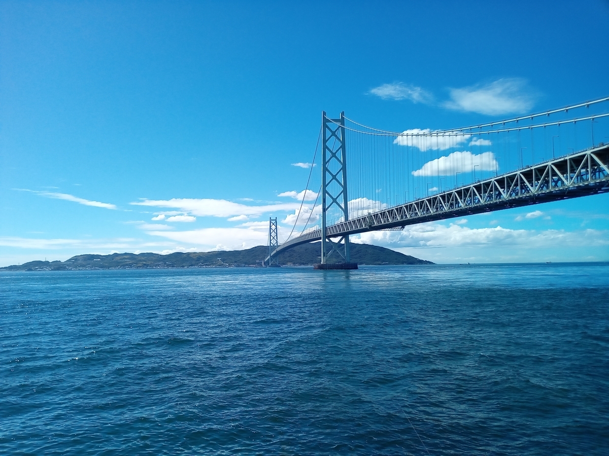
Maiko Beach, long famed for its scenic beauty and once lined with villas, faces Awaji Island across the Akashi Strait, which is about two kilometers wide. Today preserved as Maiko Park, it retains the villa Ijōkaku, built in the Taishō era by the Kobe trader Wu Jintang, evoking memories of bygone days.
Spanning between Maiko and Awaji Island is the Akashi Kaikyo Bridge, with a total length of 3,911 meters and a central span of 1,991 meters. When opened in 1998, it was the world’s longest suspension bridge. Though it has since yielded that title, its twin towers rising from the sea and massive truss deck remain overwhelmingly impressive. This site marks the western edge of Kobe’s municipal boundary, beyond which lies Akashi.
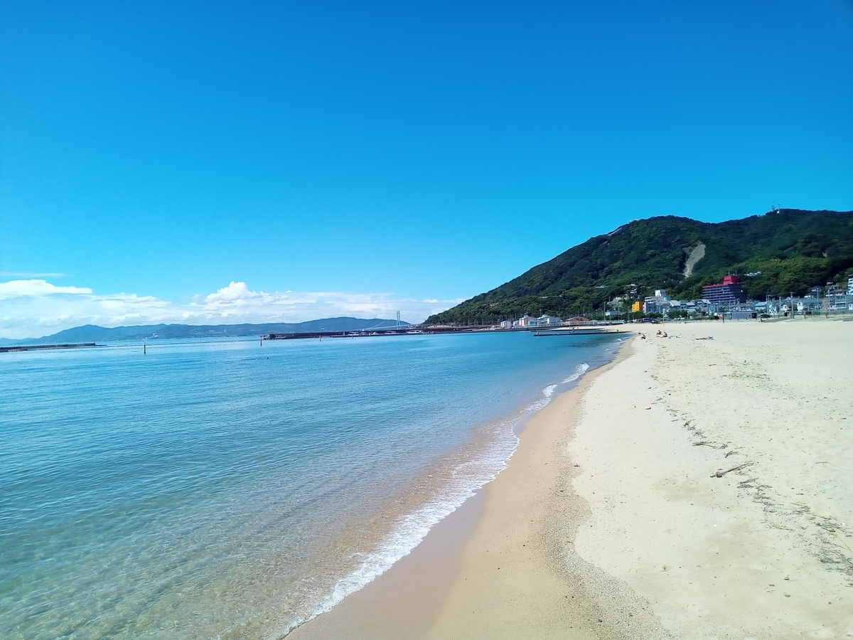
View Seven: Suma Beach
Suma Beach lies west of central Kobe, east of the Akashi Strait. Known for its white sands and green pines—its sands derived from the granite of the Rokko range—the beach is backed by pine groves. To the west rises Mount Hachibuse, where the Rokko range begins. The composition of mountain thrusting into sea, viewed across the sandy shore, resembles a mirror image of Hawaii’s Diamond Head.
A ropeway ascends Mount Hachibuse to the Sumaura Sanjo Amusement Park, from which one can see the Akashi Kaikyo Bridge to the west and the long stretch of Suma Beach extending toward Kobe’s city center to the east. As the only swimming beach in the Hanshin area, it is lively with marine sports such as yachting and windsurfing. Nearby stands Suma Sea World, where orcas and dolphins swim.
View Eight: Kobe and Osaka from Mount Rokko
Right Panel: Kobe Side

Left Panel: Osaka Side

The eighth view is the panorama of Kobe and Osaka seen from atop Mount Rokko. From elevations exceeding 900 meters along the Rokko range, which runs east–west along the northern shore of Osaka Bay, one can take in an immense panorama: Awaji Island to the west, central Kobe, Port Island, Kobe Airport, Rokko Island, the city of Osaka, and the entirety of Osaka Bay.
At night, city lights begin to glow, and the bay appears like a sea of light—long celebrated as the “ten-million-dollar night view.” Since capturing this full expanse in a single photograph is difficult, it may be likened to a folding screen, with the western half as the right panel and the eastern half as the left.
Visitors who behold this grand panorama can survey the entirety of the Eight Views of Kobe. Standing atop the long Rokko range connected to the Akashi Kaikyo Bridge, facing Awaji Island across Osaka Bay, one can grasp in vivid clarity the full figure of Kobe stretching along the mountain’s foothills—as if holding the city in the palm of one’s hand.
Kobe boasts a multitude of beautiful landscapes, each of the highest order. Yet none alone fully defines the city. Rather, its charm lies in the concentration of diverse scenic beauties within a remarkably narrow area, unified by the Rokko mountains as its backbone. The “Eight Views of Kobe” seek to crystallize this multifaceted beauty into a single coherent whole—rendering it visible, as though placed gently upon one’s palm.